The first mention of the name "Tambaroura" in the New South Wales Government Gazette was on the 27 February 1852 when the Governor General appointed Tambaroura at Tambaroura Creek as a place for holding Courts of Petty Sessions. An earlier mention in January 1852 in the Bathurst Free Press newspaper made note of an incident at "Tambaroora" Creek, this later spelling would have been an error on behalf of the correspondent/reporter. The name lasted until circa 1854 when gradually "Tambaroora" became more common. An even earlier mention was possibly made on an 1840's map noting "Tambaroura Old Station". This station appeared to be further west towards Wellington in the vicinity of the current Burrendong Dam. It's not known if that entry on the map was made in the 1840's or added at a later date.
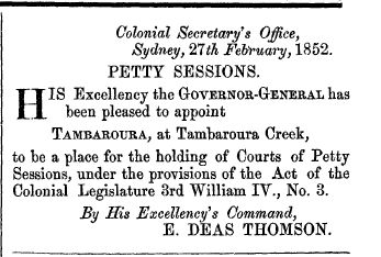
Source: (020) No.23, Pg.357, 27 Feb 1852 -
NSW Government Gazettes, by TROVE
Courtesy of the National Library of Australia
A visiting correspondent/reporter when visiting the area in October 1852 asked the origin of the name:
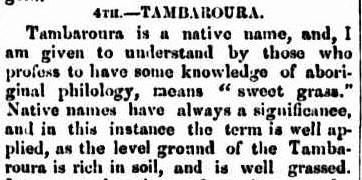
Source: (001) Pg.3, 30 Oct 1852 -
Newspapers by TROVE
Courtesy of the National Library of Australia


